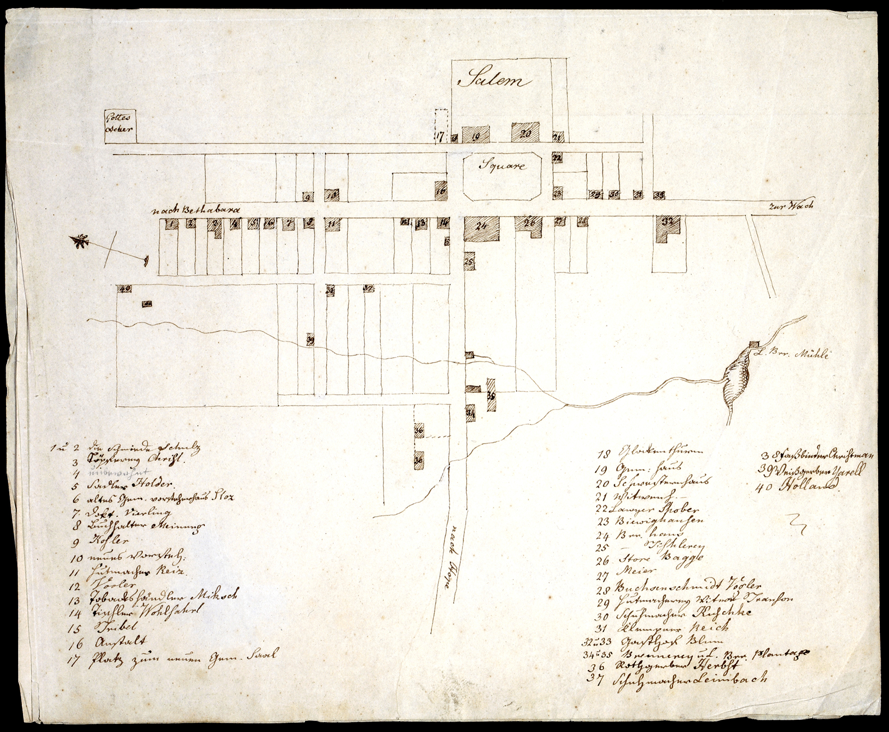
Town Plan of Salem
Framed: HOA 12; WOA 13 3/4; DOA 1 1/4
The plan shows the town as it appeared at the turn of the nineteenth century. It shows two main streets (one running ‘nach Bethabara’ to the northeast and ‘zur Wach’ to the southeast, the other ‘nach Hope’ to the southwest), a main ‘Square’ where these roads cross, some narrower side streets, a cemetery (‘Gottes Acker’), and forty buildings identified in German in a numbered key. No. 26, for example, is ‘Store Bagge’ on the ‘Square’; There is also a lake at the confluence of three streams, and a directional compass pointer.
Buildings and particular areas of note on the plan are shaded and numbered. The numbers correspond with the numbers and location names below the drawing. The translated text reads:
1 & 2 = The Smith Schulz
3 = Pottery Christ
4 = unoccupied hut
5 = Sadler Holder
6 = Old gemein vorsteher house stoz
7 = dokt Vierling
8 = Bookkeeper Meinung
9 = Kohler
10 = new Vorsteh(er)
11 = Hatmaker Reiz
12 = Cooler [Pfohl]
13 = Tobacco shopkeeper Miksch
14 = Carpenter/joiner Wohlfahrt
15 = Tribel
16 = School establishment
17 = Place for a congregation Saal
18 = Clock tower
19 = Gem. House
20 = Sisters House
21 = Widows House
22 = Lawyer Schober
23 = Biewighausen
24 = Brothers House
25 = Brethrens Workshop
26 = Store Bagge
27 = Meier
28 = Gunsmith Vogler
29 = Hatmaker Widower Transou
30 = Shoemaker Kuschke
31 = Tinsmith Reich
32 & 33 = Guest House Blum
34 & 35 = Brewery & Swgle Bros. farm
36 = Red tanner Herbst
37 = Shoemaker Leinbach
38 = Cooper Christman
39 = White tanner Yarell
40 = Holland
The map is drawn in brown ink on a quarto-page (8×9-7/8 inches), with integral blank leaf, in very good condition. The paper is English and watermarked “Smyth / 1796”.